Kandy Lake facts

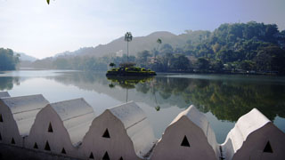
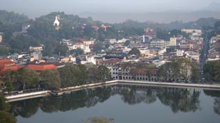
Kandy Lake, which was constructed more than 200 years ago in a valley surrounded by hills, has made the city of Kandy a picturesque sight that draws people in. The center of the island in the lake, called "Diyatilaka Mandapaya," is of latitude 7.292107 and longitude 80.640585. This island is 16 meters wide and 32 meters long.

(Slide 1 of 8 )

Kandy City Limits

The Data was compiled using Google Earth Pro Satellite image and labeling with acquired information. Use Only for General Information.

The last king of Sri Lanka, Sri Wickrama Rajasinghe, built the lake we see today known as Kandy Lake or 'Nuwara Wewa'. It was known to people from earlier times as 'Kiri Muhuda' which means Milky Sea.

Kandy Lake Round Walking Path

The Kandy Lake Round walking path was created using Google Earth Pro Satellite Map. It shows the Walking Path length (2.73 kM)and the approximate Water Surface Area of the Lake (47 Acres)

Nuwara Wewa in Kandy City

The Lake and the Kandy City can be recognized clearly from this Google Satellite Map. A part of Udawatta Forest can be seen along North East direction above the lake.

Kandy Lake Data Sheet

Since we lack proper Data on Kandy Lake, the Google Earth Pro Satellite Images were used to collect new data which appears in this Data sheet.

Kandy Lake Photos

Kandy Lake Photos
Useful Links
Links logo Kandy City Kandy Find
Links logo Udawatta Kele Sanctuary Kandy Find
Srilankaview weather Weather in Kandy Satellite Maps Find
Daraz logo Temple of the Tooth Relic Kandy Find